
Clubhouse
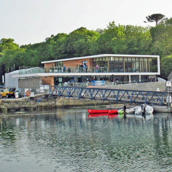
Our new Clubhouse was built for us in 2011
Our Clubhouse is located at Mylor Yacht Harbour, where Mylor Creek enters Carrick Roads. In the heart of some of the finest sailing waters in the country.
The Yacht Harbour occupies the site of the former Mylor Naval Dockyard – the smallest Royal Navy dockyard in England. Our new, purpose-built Clubhouse stands on the waterfront, adjacent to the ancient St. Mylor Church.
The Clubhouse has a comfortable lounge with a well-stocked bar, a “snug” area with a wood-burning stove, an auditorium and a training/committee room plus a terrace enjoying magnificent views of Carrick Roads and the Roseland peninsula beyond. It is active throughout the year and light lunches are available from 10.00 to 15.00 when the Club is open.
As the Clubhouse is within the bounds of the Yacht Harbour, members benefit from many excellent facilities on the doorstep. However, the Club remains independent and run by an elected Management Committee.
The Clubhouse and Marina are within easy walking distance (1¼ miles / 2km) of the village of Mylor Bridge, where there are shops for basic provisions. Alternatively, walk to Flushing (about the same distance but over the hill) and take the ferry to the centre of Falmouth for a wide range of shopping and entertainment facilities – a small supermarket is close to the ferry landing.
Although there are no bus services from Mylor Yacht Harbour, there are regular services to Falmouth, Truro and other locations from Mylor Bridge and Flushing.
Falmouth Water Taxi service runs all year round and will take you anywhere you wish to go in the estuary – so you can still get to the Pandora for a quick pint or two and not worry about who’s driving!
For those who enjoy walking, there are some delightful rambles in the vicinity. The Fal Estuary and its surroundings are an ‘Area of Outstanding Natural Beauty’ and provide an exceptionally fine area for exploration. There are numerous creeks accessible to dinghies or boats of shallow draft. It is possible to go as far as Truro by water, taking account of the tides.
Venue Hire
Mylor Yacht Club is now available to hire by members, non-members, companies and associations for Private Parties, Receptions, Conferences, Training Seminars, Product Launches, Presentations and other functions. Prices are available on application.
Set in an outstanding location overlooking Mylor Harbour and the Carrick Roads, Mylor Yacht Club is a new venue offering the perfect combination of superb position, flexible accommodation and excellent facilities
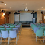
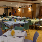
The Penrose Room:
This can be set out in lecture theatre or classroom style for business events or laid-out for buffet or seated meals as required for both business and private bookings.
The room contains a stage with presentation lectern together with a comprehensive audio-visual system including PC, drop-down screen, ceiling mounted projector and PA. The room lights are dimmable and spotlights can be provided on special request.
A folding wall allows the Penrose Room to be open to the bar and lounge or it can be easily divided off if required. For buffets, seated lunches and dinners it is usually left open and the lounge area can be used to accommodate additional tables if required.
The Chart Room:
This is a small, flexible seminar room with 12 individual tables for use as a classroom. The tables can be placed together to enable use as a conference/meeting room. It has its own audio-visual system with PC, projector and screen together with a traditional white-board for informal presentations.
Bar & Lounge:
This area houses the Club’s fully-stocked bar and a large seating area with outstanding views over the Harbour and Carrick Roads. There is also a “snug” area with woodburning stove.
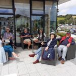
When the weather is warm enough, this room also offers access to the Club Terrace which has outdoor tables and chairs so guests can enjoy the Club’s outstanding location in comfort.
Toilets and a cloakroom are situated on the ground floor.
Catering:
Event Catering at the Yacht Club is normally handled by Castaways, though requests to use alternative caterers will be considered for Food Accredited caterers.
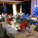


Mark Briggs – Bar Manager, and Sandy Graham – Club Manager, will be happy to help you. Drinks and light meals, and any other issues you want to discuss. Contact : Manager@myloryachtclub.org.uk. Tel 01326 374391
Menu 10.30-15.00
CLUBHOUSE MENU SPRING/SUMMER 2024
BREAKFAST
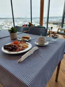
Full English Breakfast available Sat/Sun weekly from 10.00am to 12 noon
Sausage, Bacon, Fried Egg, Tomato, Cornish Hogs Pudding, Mushrooms, Beans, Toast and Coffee or Tea £10.00
Breakfast Rolls of Bacon, Fried Egg, Tomato available any day the Club is open, from 10.30am to 12 noon – from £5.00
SCRAMBLED EGG ON TOAST
Buttered toasted bloomer, 3 eggs scrambled to your liking – £6.00
LUNCH FROM 12 NOON to 3PM
SANDWICHES – YOUR CHOICE OF TOASTED OR NOT. ALL SERVED WITH A LIGHT SALAD AND LIGHTLY SALTED CRISPS
House Bloomer with salad garnish. White or delicious Malted Brown Bread.
Mature Cheddar, Tomato &/Ham – £7.50
Bacon, Brie, and Cranberry – £8.50
Tuna and Cheddar Cheese – £7.50
Stilton, Apple & Walnut – £7.50
Prawn Marie-Rose – the sauce has a hint of lemon, a shake of paprika, and a dab of Tabasco & Worcestershire Sauce – £8.50
NEW 2024 LUNCH WEEKEND ADDITIONS
Tasty Cod Goujon Sandwich on a Malted Brown Bread, with lettuce, tomato and mayo, a squeeze of Lemon Juice, and Tartare Sauce £8.00 – Add Rustic Chunky Fries
Club Sandwich – a bed of fresh Iceberg lettuce, lightly seasoned slices of tomato, on Malted Brown Bread. A dash of mayonnaise, and then filled with crispy bacon, &/or thinly sliced chicken or cooked ham. Served with a light salad mix of sliced lettuce, tomato and Braeburn apple – £8.50
Rustic Chunky Baked Fries – Just want a portion of Baked Fries – £2.50 per portion.
LIGHT SNACKS
Toasted Teacake with Butter and Jam – £2.50
Croissants – All Butter with Butter and Jam £3.00, filled with oozy Cheese & Ham £4.50
JACKET POTATOES
With salad garnish
Choice of – Beans, Cheese – £7.50
Tuna Mayo, Chilli Beef, Prawn in Marie-Rose sauce – £8.00
SALADS & PLOUGHMANS
PRAWN SALAD
Prawns in a Marie-Rose Sauce, salad , granary bread. £8.50
PLOUGHMANS
Cheddar and/or Stilton, Ham with Crusty bread, pickles and salad – £8.50
TRAY BAKES/SWEET TREATS
A selection of tray bakes, fruit scones, cakes can be found on the bar from £2.50 per portion
ICE CREAM
Individual pots of Roskilly’s Organic Clotted Cream and Vanilla, or Organic Chocolate – £1.80
SPECIALITY COFFEES – FROM £2.80 per Cup
Choose from Cappuccino, Latte, Flat White, Mocha, Americano, Espresso – with all available as Decaf, all made to order with North Coast Roast Beans from Cornish Coffee. Or indulge in a Hot Chocolate with your Sweet Treat.
*Please let us know of any special dietary requirements when ordering.
*Allergen information available.
Club Facilities
![]()
Secure WiFi is available in the Clubhouse. Please see the Steward for access details.
![]()
Guide dogs are welcome!
Other well-behaved dogs may be brought onto the terrace provided they are kept on a lead.

The Clubhouse is on the first floor.
A lift is available.

The Clubhouse is fitted with a hearing loop system.

Smoking is not permitted on the Clubhouse premises!
Sailing Directions
These notes are intended to supplement the authoritative Sailing Directions given in pilotage books. The information is provided in good faith but neither Mylor Yacht Club nor the web site editor can accept responsibility for any errors or omissions.
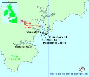
Entering Carrick Roads is generally straight-forward. The entrance lies between the St Anthony Head Lighthouse to the east and Pendennis Castle to the west. The entrance is broad and deep and partially sheltered from the prevailing westerlies by the Lizard peninsula. It can however be rough particularly when strong south-easterlies meet the ebb tide.
The principal hazard is the Black Rock shoal near the centre of the entrance. It is clearly marked by a black beacon with an “isolated danger” light Fl(2) 10s 3M. Passage can be made either side of the beacon (allowing for the shoal). The main shipping channel is to the east and is marked by a PHM (FlR2.5s).
With sufficient rise of tide Carrick Road is broad and largely free of obstructions but at LW Springs there are many shallow areas so deep-draught yachts should keep to the well-marked channel. The estuary is sheltered but strong gusts can occur in the vicinity of headlands. Tidal streams should be used to advantage to minimise the adverse effects of currents which can attain 2-3 knots in the rivers and creeks.
Note:
-
a). Large ships use the repair facilities of Falmouth Docks and are often encountered under tow.
b). The local oyster fleet dredges under sail.
c). There are numerous, highly-competitive racing events during the season.
Give them all a wide berth. -
St Anthony Head Lighthouse (Iso.W.R. 15s 22m 22/20M. W295º-004º, R004º-022º, W022º-172º) is obscured by Zone Point from the east.
-
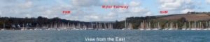
Black Rock Buoy: In 2009, the ECM shown in the photos below was replaced by a PHM
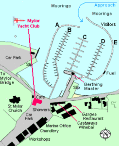
For Mylor Yacht Harbour:- Using an appropriate local chart, follow the deep-water channel through Carrick Roads until the red (R.Fl.5s) and green (Gn.Fl.6s) buoys at the entrance to Mylor Fairway bear between West and North-west. Pass between the buoys and then steer West along the fairway through the swinging moorings until the Marina Entrance bears South.
Visiting yachts are usually accommodated on Pontoon E, the Eastern Breakwater. Prior contact with Mylor Yacht Harbour Moorings Office on Channels M/M2 (37/80) is advised. “Mylor Water Taxi” (also operating on Channels M/M2) will ferry crew between the moorings and the shore.
APPROACH CHARTS:
Admiralty 2675 (English Channel)
Admiralty 442 (Lizard Point to Berry Head)
Admiralty 1267 (Falmouth to Plymouth)
Imray C10 (Western English Channel)
Imray C6 (Start Point to Lizard Point)
Stanfords 2 (English Channel Western)
Stanfords 13 (Start Point to Trevose Head)
SMALL CRAFT FOLIOS:
Admiralty SC5602 (Falmouth to Teignmouth)
Admiralty SC5603 (Falmouth to Hartland Point inc. Isles of Scilly)
LOCAL CHARTS:
Admiralty 32 (Falmouth Harbour)
Imray Y58 (River Fal)
Stanfords H23 (West Country Harbours)
LAND MAPS:
OS Landranger 204 (1:50,000)
OS Pathfinder 1366 (1:25,000)